Building an interchange at I-95 and Pioneer Trail will have a devastating affect on the quality and sustainability of the Creek, the neighboring Preserve, the New Smyrna Beach and Port Orange communities. While the Interchange won’t actually be built OVER Spruce Creek, its construction will exacerbate pollution into the watershed area which runs into the Creek. We’ll summarize the basic environmental concerns and why the Interchange is a bad idea..
Water Quality
Spruce Creek was designated as an Outstanding Florida Waterway (OFW) in 1991, meaning it has been designated by the Florida Department of Environment Protection (FDEP) under statutory authority to be “worthy of special protection because of [its] natural attributes.” Outstanding Florida Waters have special restrictions on any new activities that would lower water quality or otherwise degrade the body of water.
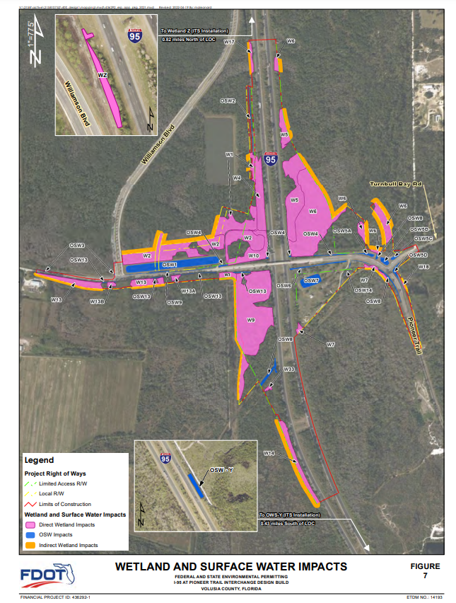
A few years ago, the Florida Department of Transportation (FDOT) expanded lanes of I-95 and an unfortunate berm break during construction caused massive amount of ‘lime-like” sediment to enter a tributary, clouding it beyond visibility. These types of accidents happen during construction and often continue once open, with the surrounding lands and waterways (including the wetlands in this Wetlands and Surface Water map from the FDOT) suffering from continued runoff and debris.
Maps are good for illustrating areas visually; however, they are unable to show the long term impacts on the overall health and biodiversity of the affected region. As an example, the significant increase in manatee deaths (many of which were in the Indian River Lagoon) aren’t caused by a single activity – it’s a cumulative build up from years of unchecked growth and related fertilizer and other toxic waste run off. Ignoring what we allow to flow into our soils and rivers slowly turns those soils and rivers deadly to fish and plant life, not the protected, healthy environments we need them to be.
Spruce Creek is ALREADY polluted, showing high levels of DO (Dissolved Oxygen), fecal coliform and other nutrients, based on these Total Maximum Daily Load (TMDL) studies from 2008.
The studies required FDEP to implement a Basin Management Action Plan (BMAP) within a year. That BMAP has yet to be produced. That means every project in the area is adding to the degradation of the water quality, without anyone understanding the full extent or the future repercussions. This is HIGHLY unusual, as almost nowhere else in the state is there a polluted OFW that does not have a BMAP to clean it up.
No, the solution to pollution ISN’T dilution. While this pithy saying rhymes well, it couldn’t be further from the truth as was proven back in 1969 when the Cuyahoga River caught fire because people had been dumping all their chemicals there. This ecological disaster inspired the creation of NEPA (National Environmental Policy Act) in 1970, which established the U.S. Environmental Protection Agency (EPA). The EPA significantly revised the Federal Water Pollution Control Act of 1948, renaming it the Clean Water Act in 1972. Yes, the Clean Water Act which requires state to submit to the US EPA a list of surface waters that do not meet applicable water quality standards and establish a TMDL for each pollutant causing impairment.
How this Interchange, with its obvious impacts, has even made it to a permitting stage has us shaking our heads.
Doris Leeper Spruce Creek Preserve
Named for the acclaimed artist and conservationist, the 2,500 acre Doris Leeper Spruce Creek Preserve contains a number of imperiled ecosystems including scrub and maritime hammock, as well as threatened bird, plant, and other animal species. Purchased with funds from sources including Preservation 2000, Florida Forever, Florida Communities Trust, and Volusia Forever, the 2021 Spruce Creek Florida Forever Five-Year Plan designates the section of land where the Interchange is planned an “Essential Parcel” for the Preserve, as noted in Green in the map below.
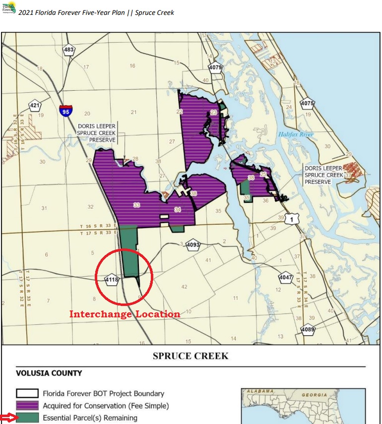
Without that remaining parcel, the entire investment in the Preserve is in peril, especially since the corridor will be cut off for animals to enter and leave. The Florida legislature unanimously approved the establishment of a Florida Wildlife Corridor to protect the state’s interior greenways that are vital to animal migration. We suggest adding this parcel to the Preserve to protect it forever.
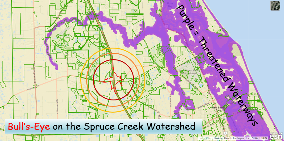
The area of the proposed interchange is circled in red on the map above which was taken from the St. John’s River Water Management District’s (SJRWMD) website (with added text and circles for clarity). This illustrates in detail the impact of the construction, traffic, and subsequent development that the interchange creates.
The land AROUND Spruce Creek will sustain damage and loss and consequently impact the Creek. The soil in this area actually filters the water, holding onto pollutants such as living organisms, harmful chemicals, and minerals, and only lets clean water through. The surrounding dirt actually cleans the water, when it’s allowed to do its job and isn’t covered up in concrete.
The FDOT Interchange Justification Report (IJR) specifically acknowledges the purpose of this interchange. “ . . .is to support the economic viability and job creation associated with planned and future development in the vicinity of the study area, to reduce congestion at the adjacent I-95 interchanges, and to better serve regional trips . . .”
Basically, the report is saying the primary “purpose” of the interchange is to open the area to future development. The future impacts of this expensive (now $80 million) project will cost more in loss of habitat, wildlife, and the future cost of the environmental clean up, and won’t reduce congestion to any noticeable degree or deliver the economic boom the promoters predict. Let’s instead spend a fraction of that amount and add that property to the Preserve, protecting it from future developmental impacts forever.
Traffic & Safety Concerns
Initial claims regarding the benefits this interchange would bring to traffic flow have been adjusted by FDOT. The last published numbers indicated a statistically meaningless ~13% improvement in Dunlawton traffic by 2045. Adding an on-ramp at Pioneer Trail won’t do much to help SR-44 or Dunlawton, but it will destroy forever the beauty, harm, and ecological health of Pioneer Trail. Essentially, it will only duplicate the same problem there.
Additionally, another interchange between SR 44 and SR 421 (Dunlawton Ave.) pushes the limit of the FHWA Access Management Manual guidelines, which recommend a minimum of 3 miles between interchanges in urban areas and 6 miles in rural areas. This interchange would create 3 interchanges in 6 miles with barely three miles between each.
New Smyrna Beach and other Volusia County residents overwhelming expressed their opposition to this interchange during public meetings in 2018 and 2020, and yet the project was allowed to proceed with the support of some uninformed local politicians.
Future Development
Williamson Blvd. and the plans for its future extension will further wreak havoc on the area, as the stated intention is for it to expand many more miles through the heart of Farmton, also known as the largest wetland mitigation bank in the country. A Sierra Club challenge to the approval by the SJRWMD and Army Corps of Engineers (ACOE) to allow certain portions of the Farmton Mitigation Bank to be converted to a mixed-use development was denied.
Stopping this interchange will go a long way toward protecting this Outstanding Florida Waterway, the legacy of the great Doris “Doc” Leeper, and the endangered scrub jays, manatees and other wildlife that call this area home.
We invite your input. Please share your comments below and click here for more ways to help.
Leave a Reply